Le Pouce Mountain
The island's third peak (812 m), shaped like a raised thumb and once climbed by Charles Darwin. An accessible hike (2h30-4h return from La Laura) ending in a short rocky scramble and an unforgettable panorama.
Tip: Start early, the summit clouds over by late morning. The final step needs hands.
Why hike Le Pouce
At 812 m, Le Pouce ("the Thumb") is the third-highest peak in Mauritius and one of the easiest to reach. It is named after the thumb-shaped rock that tops the Moka range, between Pieter Both and Signal Mountain.
Charles Darwin climbed it on 2 May 1836 during the Beagle's stopover and wrote about the island's basalt geology in his diary. From the top you get a full panorama over Port Louis and its harbour, the Moka plateau, Beau Bassin-Rose Hill and, on clear days, the islets off the north coast.
Route and hiking time
The standard route starts on the south side above the village of La Laura-Malenga in Moka district: roughly 4 to 5 km return with just under 400 m of ascent on a marked trail. Allow 2.5 to 4 hours return depending on your pace and time at the top.
A northern route climbs from the outskirts of Port Louis. It is more than twice as long with more ascent, but shadier and more gradual; plan half a day and arrange transport if you do not return the same way.
Difficulty: the final scramble
Most of the trail is an easy to moderate walk. The last stretch below the "thumb" is much steeper, with high rocky steps where you will use your hands; there are few fixed aids, so it is not for anyone with a fear of heights.
Coming down this section is often trickier than going up, especially after rain when rock and soil turn slippery. Wind at the summit can be strong, so keep a firm hold on belongings and children.
Practical info and best time
The hike is free and needs no permit or guide (checked October 2026), although local operators run guided outings. There is no water or toilet on the way: carry at least 1.5 litres per person, wear shoes with good grip and pack sunscreen and a windbreaker.
Start early, ideally before 8am: cloud often wraps the summit by late morning and the exposed sections heat up quickly. The drier, cooler southern-hemisphere winter brings the best conditions. Stay on the trail, as the mountain shelters threatened endemic plants.
What to combine it with
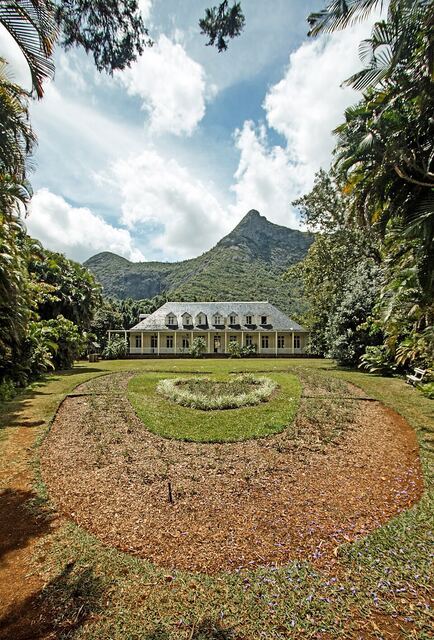
After the hike, Eureka House in Moka is a short drive away for a Creole lunch on the veranda. From the summit you will also have eyed neighbouring Pieter Both, with its balanced rock head, whose final climb requires a guide.
Less experienced walkers may prefer Signal Mountain above Port Louis, followed by a visit to Port Louis Central Market.
Frequently asked questions
How long does it take to hike Le Pouce?
From La Laura, allow 2.5 to 4 hours return for roughly 4 to 5 km and just under 400 m of ascent.
Is Le Pouce a difficult hike?
It suits anyone reasonably fit, but the final few metres are steep and need hands. Avoid it if you have vertigo or after heavy rain.
Do you need a guide for Le Pouce?
No, the trail is marked and free to use. A guide is still useful if you are new to mountain walking or plan the longer northern route.
When is the best time to climb Le Pouce?
Early morning in dry weather, ideally during the southern winter. The summit often clouds over by late morning.